History of Boston's Swamps
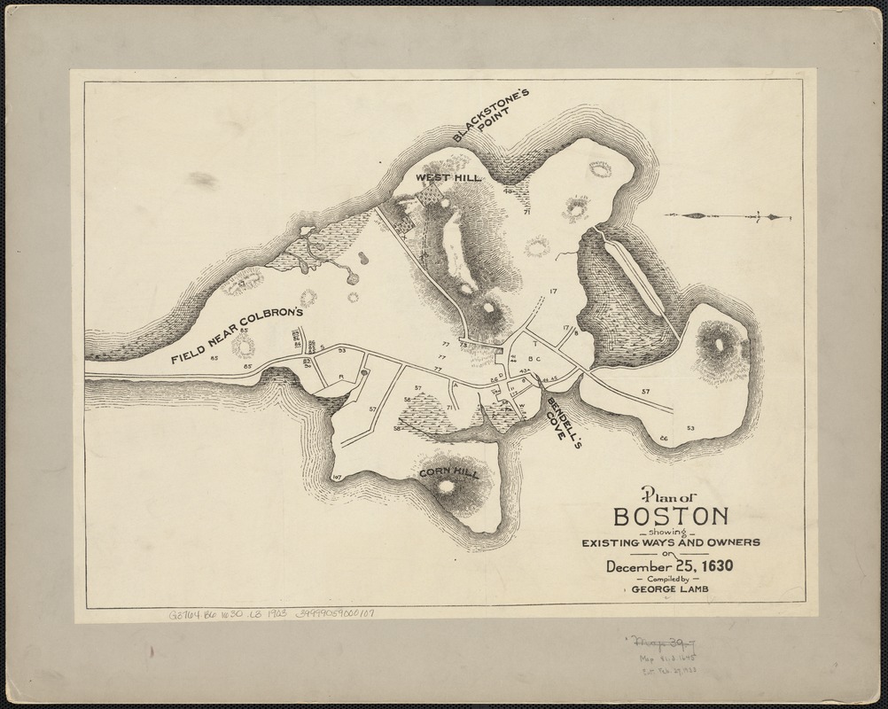
Before colonial settlers arrived in 1630, the native Algonquin people residing in what is now downtown Boston referred to this land area as Shawmut. As the English were arriving to the area, Shawmut was an 800 acre peninsula that was connected to the mainland by a narrow strip of land called “The Neck”. Shawmut Peninsula had three large hills (that have since been flattened) and were called “Trimount”, a precursor to the name for Tremont street.
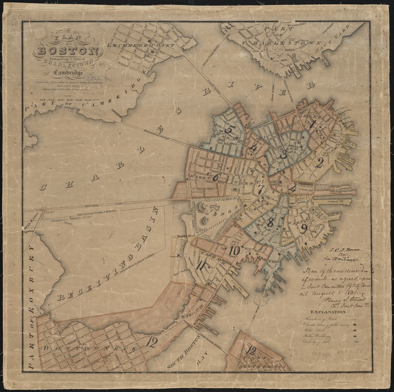
During the late 1700's, Boston was coming into its own as a shipping center, so more land around the harbor was filled in to create docks and bridges. When the English first landed in what is now Boston, the area around the future North Station was just a large, marshy cove called Mill Pond. Sometime after 1643, the cove’s ownership changed, and a large dam was built, allowing the entire cove to eventually be filled in. Later, the West Boston Bridge was build to connect the peninsula to Cambridge, in the same location as the current day Longfellow Bridge. In 1785, a similar bridge was built to connect Boston to Charlestown. By 1795, Boston was growing to be more interconnected, allowing quick access to neighboring towns.
By 1852, larked areas of the greater Boston area were filled in. The prevailing medical theory at the
time was miasmatic theory of disease, which posited that disease was caused by foul odors. This proved
to be a reason for filling in swampy areas of Boston that had started to smell wretchedly.
In 1807, due to public health concern over the stench of Mill Pond, the filling in of the pond began.
Mill Pond was located in what is now known as the West End. The material for this came from Beacon Hill,
resulting in Beacon Hill becoming 60 feet lower than it was before the city started tearing up the land
to use for filling in. This land became an industrial area and land was eventually extended outwards
even more to make room for railroad depots.
South Cove (current day Chinatown) and Great Cove (current day Financial District) started to be filled
in 1806 and continued into the 1840s.
Back Bay is another area that is the result fo extensive filling in. In 1822, a dam was constructed in
the Back Bay area in order to power mills. This stopped the flow of water and caused areas of land to
start appearing soon after, including what is now the Boston Public Garden and the area south of the
garden called Bay Village. The area was described as “bubbling like a cauldron with the noxious gases
that are exploding from the corrupting mass below” and residents pushed to get this area filled in. Once
again, the stench of sewage became the cause for filling in an area of Boston. By 1850, the landfill of
Back Bay was approved.
By 1880, the area currently known as Back Bay was almost fully filled in, with the exception of the
Esplanade. The filling of Back Bay started in 1857 and was completed in 1882. The act of filling in Back
Bay nearly doubled the size of the Boston peninsula. The land was filled in using gravel imported from
Needham, rubble from the Great Fire of 1872, mud and trash.
The filling of Charlestown occurred between 1860 and 1896, turning the land from a peninsula into mostly
connected to the mainland of Everett.
Part of downtown Boston and the South Bay Area started to be filled in during the 1850’s.
By 1890, the Charles River landfill reached Kenmore Square, which used to be the west end of the Back
Bay Milll pond.
The filling of the Back Bay Fens was complete in 1900. This area had been a tidal flat of the Charles
River but was filled in after becoming malodorous from sewage from nearby settlements. The famous
landscape architect Fredrick Law Olmsted worked on turning the Fens area from a smelly swamp into a
hygienic park with some of the marsh preserved for ecological purposes. He designed the area to be
fleshed by the tides twice a day, but in 1910 a dam was built to close the area to ocean tides and form
a freshwater lagoon where storm water from the Charles River Basin flowed into.
By the late 19th century, the salt marshes of East Cambridge were filled in, allowing East Cambridge to
join with Old Cambridge and Cambridgeport. Evidence that East Cambridge sits atop filled land can be
seen in the street patterns of the area. The street grid of this area (south of Charles Street and west
of Sixth Street) is far more open than the original land above it.
In 1916, the MIT campus was moved from Boston to its current location in Cambridge because of the allure
of greater land area. The new campus was located on a mile long tract of filled land on the Cambridge
side of the Charles River.
In 1929, the first flight took off from Boston Logan Airport, which was built on an area of filled in
land in East Boston.
The filling in of the Columbus Park/Andrew Square was completed by 1934.
During the 40s and 50s, the rise in air travel led to the area around Boston Logan Airport to be
expanded via landfilling. The land was taken from Governers, Noddle’s and Apple islands. Due to this
process, these islands no longer exist. This allowed Logan Airport to add 2 terminals in 1949.
By 1950, much of the Belle Isle marsh was filled in - leaving the Belle Isle Marsh Reservation as the
last remnant within Boston of the salt marshes that were once prevalent along the Massachusetts Bay
Shoreline. Much of this reclaimed land is now Orient Heights, a largely Italian and increasingly South
American neighborhood.
Between 1950 and 1995, many finishing touches were made to Boston’s shoreline that are transportation and recreation staples for Bostonians to this day. These include the final additions to the Esplanade park, the construction of the Evelyn Moakley Bridge connecting Downtown Boston to Seaport, and large additions to Boston Logan International Airport used to extend runways to accommodate new, larger planes. The Seaport district was fleshed out, and the landfill at Columbia Point was closed and the area converted to land for housing, parks, and UMass Boston’s Harbor Campus.